Denpasar to Brisbane Flight Time, Distance, Route Map
Flight time from Denpasar, Indonesia to Brisbane, Australia is 5 hours 34 minutes under avarage conditions. Our flight time calculator assumes an average flight speed for a commercial airliner of 500 mph, which is equivalent to 805 km/hr or 434 knots. Actual flight times may vary depending on aircraft type, cruise speed, routing, weather conditions, passenger load, and other factors.
What is the Flight Distance Between Denpasar and Brisbane?
The flight distance from Denpasar (Indonesia) to Brisbane (Australia) is 2786 miles. This is equivalent to 4483 kilometers or 2419 nautical miles. The calculated distance (air line) is the straight line distance or direct flight distance between cities. The nearest airport to Denpasar, is Ngurah Rai Airport (DPS) and the nearest airport to Brisbane, is Brisbane Archerfield Airport (ACF).
Denpasar - Brisbane Timezones & Time Difference
Current local time in Denpasar is 2025-05-18, 21:40:23 WITA
Current local time in Brisbane is 2025-05-18, 23:40:23 AEST.
Time difference between Denpasar (Indonesia) and Brisbane (Australia) is 2 Hours.
Brisbane time is 2 Hours ahead of Denpasar.
Denpasar to Brisbane Flight Route Map
Flight map from Denpasar, Indonesia to Brisbane, Australia is given below.Click the map to view Denpasar to Brisbane nonstop flight path and travel direction.
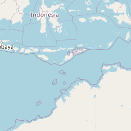 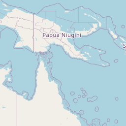 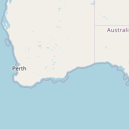 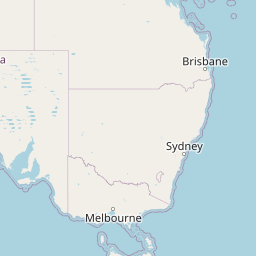 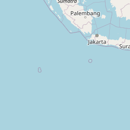 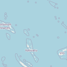  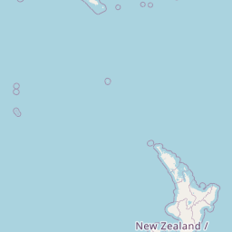  Leaflet | © OpenStreetMap The distance between cities calculated based on their latitudes and longitudes. This is also called distance as the crow flies. Bird flight distance is calculated by drawing a straight line between two point coordinates. The length of this drawn line will give the shortest distance value. This distance may be very much different from the actual travel distance. Denpasar GPS Coordinates: Latitude: S 8° 40' 13.6'' Longitude: E 115° 12' 45.5'' Brisbane GPS Coordinates: Latitude: S 27° 28' 15.6'' Longitude: E 153° 1' 24.4'' Denpasar Map, Where is Denpasar located? Brisbane Map, Where is Brisbane located? |
Popular Searches from Denpasar
- Denpasar to Yogyakarta flight time, duration and distance
- Denpasar to Surabaya flight time, duration and distance
- Denpasar to Sumbawa flight time, duration and distance
- Denpasar to Semarang flight time, duration and distance
- Denpasar to Purwokerto flight time, duration and distance
- Denpasar to Palembang flight time, duration and distance
- Denpasar to Mataram flight time, duration and distance
- Denpasar to Malang flight time, duration and distance
- Denpasar to Praya flight time, duration and distance
- Denpasar to Lombok flight time, duration and distance
- Denpasar to Kupang flight time, duration and distance
- Denpasar to Jembrana flight time, duration and distance
- Denpasar to Tangerang flight time, duration and distance
- Denpasar to Gilimanuk flight time, duration and distance
- Denpasar to Buleleng flight time, duration and distance
- Denpasar to Batam flight time, duration and distance
- Denpasar to Bangli flight time, duration and distance
- Denpasar to Bandung flight time, duration and distance
- Denpasar to Balikpapan flight time, duration and distance
- Denpasar to Kota Atambua flight time, duration and distance
Popular Searches from Brisbane
- Brisbane to Vancouver flight time, duration and distance
- Brisbane to Honolulu flight time, duration and distance
- Brisbane to Perth flight time, duration and distance
- Brisbane to Tokyo flight time, duration and distance
- Brisbane to Apia flight time, duration and distance
- Brisbane to Nadi flight time, duration and distance
- Brisbane to Suva flight time, duration and distance
- Brisbane to Suva flight time, duration and distance
- Brisbane to Suva flight time, duration and distance
- Brisbane to Nouméa flight time, duration and distance
- Brisbane to Viti flight time, duration and distance
- Brisbane to Nouméa flight time, duration and distance
- Brisbane to Nadi flight time, duration and distance
- Brisbane to Denpasar flight time, duration and distance
- Brisbane to Doha flight time, duration and distance
- Brisbane to Tokyo flight time, duration and distance
- Brisbane to Los Angeles flight time, duration and distance