Semarang to Cilacap Flight Time, Distance, Route Map
Flight time from Semarang, Indonesia to Cilacap, Indonesia is 0 hours 12 minutes under avarage conditions. Our flight time calculator assumes an average flight speed for a commercial airliner of 500 mph, which is equivalent to 805 km/hr or 434 knots. Actual flight times may vary depending on aircraft type, cruise speed, routing, weather conditions, passenger load, and other factors.
What is the Flight Distance Between Semarang and Cilacap?
The flight distance from Semarang (Indonesia) to Cilacap (Indonesia) is 109 miles. This is equivalent to 174 kilometers or 94 nautical miles. The calculated distance (air line) is the straight line distance or direct flight distance between cities. The nearest airport to Semarang, is Achmad Uani Airport (SRG) and the nearest airport to Cilacap, is Tunggul Wulung Airport (CXP).
Semarang - Cilacap Timezones & Time Difference
Current local time in Semarang is 2025-12-06, 10:25:22 WIB
Current local time in Cilacap is 2025-12-06, 10:25:22 WIB.
Time difference between Semarang (Indonesia) and Cilacap (Indonesia) is 0 Hours.
Semarang to Cilacap Flight Route Map
Flight map from Semarang, Indonesia to Cilacap, Indonesia is given below.Click the map to view Semarang to Cilacap nonstop flight path and travel direction.
        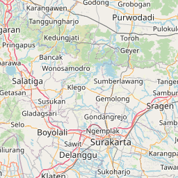        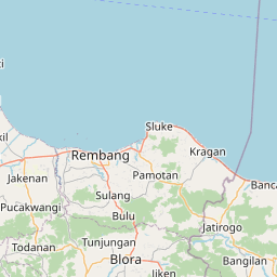    Leaflet | © OpenStreetMap The distance between cities calculated based on their latitudes and longitudes. This is also called distance as the crow flies. Bird flight distance is calculated by drawing a straight line between two point coordinates. The length of this drawn line will give the shortest distance value. This distance may be very much different from the actual travel distance. Semarang GPS Coordinates: Latitude: S 7° 0' 18.5'' Longitude: E 110° 26' 17.3'' Cilacap GPS Coordinates: Latitude: S 7° 41' 53.9'' Longitude: E 109° 1' 24.7'' Semarang Map, Where is Semarang located? Cilacap Map, Where is Cilacap located? |
Popular Searches from Semarang
- Semarang to London flight time, duration and distance
- Semarang to Chennai flight time, duration and distance
- Semarang to Temanggung flight time, duration and distance
- Semarang to Tegal flight time, duration and distance
- Semarang to Sukoharjo flight time, duration and distance
- Semarang to Sragen flight time, duration and distance
- Semarang to Surakarta flight time, duration and distance
- Semarang to Sleman flight time, duration and distance
- Semarang to Rembang flight time, duration and distance
- Semarang to Purworejo flight time, duration and distance
- Semarang to Purwokerto flight time, duration and distance
- Semarang to Pemalang flight time, duration and distance
- Semarang to Pekalongan flight time, duration and distance
- Semarang to Pati flight time, duration and distance
- Semarang to Pacitan flight time, duration and distance
- Semarang to Magelang flight time, duration and distance
- Semarang to Wates flight time, duration and distance
- Semarang to Kudus flight time, duration and distance
- Semarang to Klaten flight time, duration and distance
- Semarang to Kendal flight time, duration and distance